

Mountain running in Chile
Santiago, June 2017
I was lucky enough to arrange a short work sabbatical in Santiago, Chile in May 2017. I was researching air pollution and the effect of the Andes on understanding its circulation and transport in the surrounding areas and my first day at work happened to be on the city’s first Pre-emergencia air quality warning, halting school gym lessons and limiting traffic in certain areas. My land lady happened to mention that there was an old bike I could borrow so I covered many miles on this during my stay, braving the smog and the rather hectic traffic commuting to the University of Chile in the centre of town every day.
_JPG.jpg)
Santiago has a population of 7 million (40 % of the whole country). Here you can see the smog over the city that is blocked in by the mountains.
Well before I left, I was already researching the travel and mountain exploring possibilities. 12 years ago I had done been to Patagonia (Torres del Paine and the South Patagonian ice field) and to Baňos Morales near Santiago but this time, on my own and without mountaineering equipment, I decided my trainers and some warm clothes would have to suffice to get me up any mountains. I soon realised that I could do plenty of day trips at weekends and get into some exciting terrain which high up had got its first coverings of southern hemisphere winter snow.
I contacted the Santiago Mountain Running Co. (STGOMRCO)1 to see if I could join them for evening training sessions and in the hope of getting some company in the hills at weekends. I was told I was very welcome and enthusiastically followed their social media posts in the run up to my trip, noting down the places I had seen them in that I had to visit!
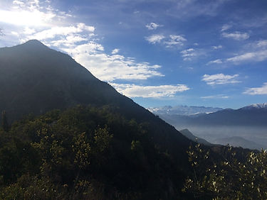
I chose my accommodation to be close to the forested urban park and the hill of San Christobal that has a cable car and funicular running up to the top. On my first weekend I explored that area and carried on through the park to get to Cerro Carbon, an extension of the park and 1300 m high, affording a great view of the city (600 m high).


_PNG.png)
Santiago has a population of 7 million (40 % of the whole country). Here you can see the smog over the city that is blocked in by the mountains.
Well before I left, I was already researching the travel and mountain exploring possibilities. 12 years ago I had done been to Patagonia (Torres del Paine and the South Patagonian ice field) and to Baňos Morales near Santiago but this time, on my own and without mountaineering equipment, I decided my trainers and some warm clothes would have to suffice to get me up any mountains. I soon realised that I could do plenty of day trips at weekends and get into some exciting terrain which high up had got its first coverings of southern hemisphere winter snow.
I contacted the Santiago Mountain Running Co. (STGOMRCO)1 to see if I could join them for evening training sessions and in the hope of getting some company in the hills at weekends. I was told I was very welcome and enthusiastically followed their social media posts in the run up to my trip, noting down the places I had seen them in that I had to visit!
I chose my accommodation to be close to the forested urban park and the hill of San Christobal that has a cable car and funicular running up to the top. On my first weekend I explored that area and carried on through the park to get to Cerro Carbon, an extension of the park and 1300 m high, affording a great view of the city (600 m high).
_JPG.jpg)
Parque Aguas de Ramon
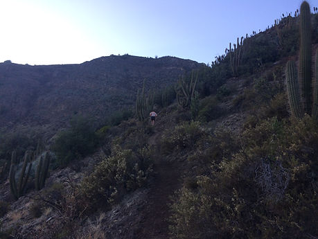
The next weekend I headed off to Aguas de Ramon park, across over on the Eastern side of the city, from which white-topped mountains rise. The Cordillera parks are a network of parks on Santiago’s fringes and allow conservation, environmental education and tourism to keep these wild areas so close to the city as safe and untainted as possible. There is a small charge to enter and you have to leave your details and the intended route you will take. The gates close at 5 so they make sure that everyone is safe and accounted for. I learned that as a runner it is best to get there early as the single-track trails make passing difficult. I was told that I needed to get to a ranger- attended point by 10.30 if I wanted to be allowed on to the furthest point on the trail so I set off at a blazing pace, only to realise at 10.45 that I hadn’t actually noticed that I had gone past the checkpoint a fair distance back. I relaxed and carried on the lovely run past cactuses and Mediterranean vegetation as it went over a few viewpoints and then passed over and across a large canyon and ends up at a waterfall at the foot of a cliff face. The next day I headed to Cerro Manquehue (1638 m), a hill looming over the city that looks so impressive from the eastern side. I was beginning to recognise the hills and feel proud when I could see one that I had been up! Whilst up there I talked to some people on the top who told me that there had been a few muggings on the ridge beneath this hill but I need not worry, they were arrested 2 weeks ago. Hmm, this made me aware I was being quite naïve and trusting, running around on my own, an obvious foreigner in these hills.
_JPG.jpg)
_JPG.jpg)
_JPG.jpg)
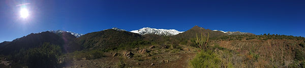
Cerro Manquehue and Cerro Carbon: towering above the city
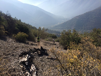
On the Saturday of my last weekend saw an early start for the club to meet in the outskirts of the city (the first time I didn’t cycle the 15 km out of time and got a lift!!) and about 20 of us headed up towards the Alto de Naranja. I didn’t know how the session would run but knew that some of the faster ones were intended to go up the path to Cerro Provincia, a real classic. I assumed we would regroup at some point but the run seemed to turn into an individual race and I just kept the person in front and the person behind in sight and joined in the challenge and climbed the 12 km and 1800m to the top.
It was freezing in the shade before 8 am but once on the ridge to the top the sun allowed me to be in a T-shirt, only to be hit by blasts of freezing air as I hit the snow level just over 2000 m. The path wasn’t too obvious as the snow had hidden some of the markers and I was pleased as I put some more layers on to be caught up by a club mate and we tackled the final rocky scrambles in between the hard-packed snow gulleys and ended up on the summit plateau where we met the fastest people turning round and descending as it was too cold to regroup up there! Summit photos and I and my camera got too cold and had to head back. The paths in Chile are often quite loose dry earth and gravel, not something I am very used to from the UK so I was a bit cautious on the steepest ones but eventually it became a wonderful swooping descent all the way back down to where the club started. We were cheered in (I got a bit lost in the final little tracks at the bottom) individually and I felt so happy to have done such an epic run.
_JPG.jpg)
_JPG.jpg)
_JPG.jpg)
_JPG.jpg)
Cerro Provincia (2750 m)
For my last weekend I had wanted to do something really special so I set about trying to hire some skis for some ski touring up near the ski resorts of nearby Farellones. I went to the outdoor shops, ski rentals and contacted some tour companies and guides and eventually gave up. It sounded like it was still early season for that and I was unlikely to find all the right kit for it. During my search, my running friends recommended me to contact an English guy living in Santiago who might know about ski touring. So I got in touch with Matt, an adventure, travel and environmental journalist (with an interest in air quality too3) and when the skiing idea fell flat he suggested an adventure run for the weekend and I couldn’t say no!
_JPG.jpg)
_JPG.jpg)
Biking and running- best way to get into the middle of nowhere
On the Sunday I started cycling to the outskirts of town (uphill) before the sun had risen to meet Matt. I had warned him my bike was a bit old and creaky and that my legs would be a bit tired but he turned up with his French friend, Fabien on a tandem mountain bike that was also probably from 1990! They had been out running the day before too - everyone I was meeting was mad for it here! I desperately followed them up the ski road towards Farellones- a tandem is pretty fast once it gains momentum. We turned off after 10 km and headed through a gate and along a jeep track before eventually stashing away our bikes and turning into running mode.
_JPG.jpg)
Cerro Terremoto- the perfect adventure day out
_JPG.jpg)
_JPG.jpg)
_JPG.jpg)
We did a circular tour up Cerro Terremoto, skirting around some beautiful hillsides above a river. A fair bit of bush-whacking but there was often a path to follow but our wikiexplorer route helped edge us in the right direction and then we turned up to the final climb to the summit. The snow was a lot softer than the day before, much less wind-packed so there were no technical difficulties and we enjoyed our time on the summit before a joyful and gentle descent along a ridge with 2 minor summits. We had seen eagles and huge black birds (we assumed condors and smaller vultures) but it was whilst running down the ridge with them swirling above us that we really experienced the sheer size of a condor as one swooped out of nowhere on a smaller bird that I was watching. It must have been in his viewing space as he soared above. The sound of the beating wings and how close they were to us was just stunning. They stayed above us, using the afternoon thermals.
The rest of the run was a bush-whacking, try-to-stay on-your-feet steep and loose descent where as you lost control you could see a cactus looming beneath you.. I am still pulling out spiky bits from my hands and am covered in scratches (not the cactuses!) but it was good fun and we were following our noses back down to the spot we left our bikes. Wow, great day out with great company and then we cycled back along a high bridleway instead of take the road back- I stumbled back to my house as the sun was setting- I had really squeezed all I could out of my time in Chile; the work had worked out well, I had done lots of training, seen incredible mountains, had loads of adventure and meet some real cool people.
References
2) http://asociacionparquecordillera.cl/red-de-parques-naturales/
3) http://matt-maynard.com/subiendo-al-aire-limpio/
More information:
More photos in facebook album and photos from January 2018 here.
Maps and information on routes in Andeshandbook

The locations of my runs shown as yellow and blue stars.
Aconcagua is 100 km north east of Santiago and is the highest mountain in South America.
There are many 5000 or 6000 m peaks on the Chile-Argentina border
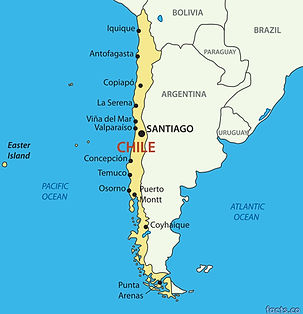
Chile is 4000 km long but mostly less than 300 km wide

Zooming into the city you can see all the mountains and parks to the North and east of the city
that I visited.
Originally written for the Pennine fell runners website